Imagine a bunch of computer programs trying to guess where a storm will go. Each program comes up with a different path, like different colored strings. When all these colored paths are shown on a map together, they look a bit like spaghetti strands, hence the name “spaghetti models.” In this article, we will discuss and review the recently viral Hurricane Lee’s Spaghetti Models. But before we talk about that, let’s know what they are used for?
Spaghetti models help us understand the uncertainty of a storm’s path. They show us a range of possibilities, not just one exact track. This is important because weather forecasting isn’t perfect, and storms can sometimes change direction unexpectedly.
Now let’s see who they are meant for? Anyone can look at spaghetti models! They are designed to be informative for a general audience. However, it’s important to understand that they shouldn’t be confused with an official forecast.
Understanding Hurricane Lee Spaghetti Models
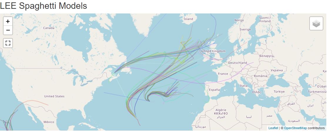
Hurricane Lee, which reached Category 5 strength at its peak, serves as a recent example of a powerful Atlantic storm. Fortunately, the hurricane weakened before making landfall, transitioning into a post-tropical cyclone. It brought hazardous surf and rip currents to the eastern coast of the United States before making landfall in Canada. Using the spaghetti graph, the storm was expected to track near the northern New England coast, potentially impacting that region.
This event highlights the importance of understanding spaghetti models, which are computer-generated forecasts that depict a range of possible paths a storm might take. Lee weakened before landfall, so the actual impacts are not as severe as a Category 5 storm. The impact was bringing “hazardous surf and rip currents” to the US coast, so potential dangers were predicted but not widespread destruction.
I reviewed Hurricane Lee’s Spaghetti Models myself and I understood that the cyclone could affect Canada’s South-East region, USA’s North-East regions, and Northern United Kingdom.
The highest predicted wind speed for Hurricane Lee is 87 knots. This translates to roughly 100 miles per hour (mph) or 161 kilometers per hour. At 100 mph, hurricane’s winds can cause significant damage. Power lines and trees can be downed, leading to power outages and blocked roads. Some buildings may sustain roof damage, and weaker structures may be damaged or destroyed. Depending on the location and other factors, authorities may order evacuations for people in areas at high risk from the storm. If the storm makes landfall near high tide, a surge of water can inundate coastal areas. This surge can be very dangerous and can cause significant property damage and loss of life.
However, It is just an unofficial prediction according to the spaghetti model generated by computer programs that collect data using satellites, radio signals and visual images and environmental conditions like change in air’s speed. For more accurate information on the potential impacts of Hurricane Lee, it is recommended to follow advisories from official sources like the National Hurricane Center (https://www.nhc.noaa.gov/) and local emergency management agencies.